 |
|||||
|
|
|||||
|
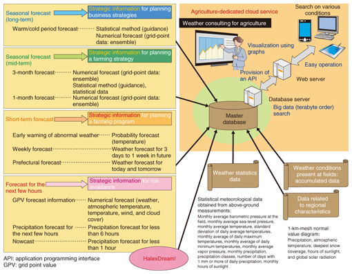
Feature Articles: NTT Group Activities in the Agricultural Field Vol. 14, No. 6, pp. 35–40, June 2016. https://doi.org/10.53829/ntr201606fa6 NTT Group Activities to Support Smart AgricultureAbstractThe NTT Group is committed to strengthening the competitiveness of Japanese agriculture and is therefore supporting the implementation of smart agriculture through the use of information and communication technology. This article introduces the exhibits presented by NTT Group companies at AGRINEXT 2015 (held October 14–16, 2015 at Makuhari Messe) as examples of the group’s activities related to the natural environment. Keywords: weather, geography and terrain, wild animal damage 1. IntroductionBecause most agricultural products are grown in outdoor fields, agriculture is one of the industries that is most sensitive to the elements of the natural environment. Such elements include weather, geography and terrain, and wild animals. There are major variations in Japan’s natural environment from region to region because the archipelago runs in a long 3800-km arc from north to south, is filled with mountains and valleys, and is affected by ocean currents on all sides. If Japanese agriculture is to improve its competitiveness, producers need to practice farming that is adapted to the natural environment of the particular region. This article introduces three activities of the NTT Group concerning weather, geography and terrain, and wild animal damage. These activities were exhibited at AGRINEXT 2015 held October 14–16, 2015 at Makuhari Messe in Chiba Prefecture. 2. Activities related to weather informationFrom ancient times, agriculture is said to have been at the mercy of the weather, and this still holds true today even though there have been great advances in agricultural technology. Crop yields vary year by year along with changes in climate and weather. In recent years, extreme weather events such as high temperatures and torrential rain have been occurring more frequently, causing serious damage to agriculture. In September 2015, for example, the intense rainfall in the Kanto and Tohoku regions (brought about by Typhoon No. 18) caused damage estimated at 4.84 billion yen. This serves as evidence of how serious weather-related damage can be [1]. To tackle this problem, Halex Corporation, an NTT Group company, has developed a meteorological data optimization system called HalexDream!. The system processes a huge volume of meteorological data provided by the Meteorological Agency in order to produce agriculture-related weather information that is specifically designed to support farming activities. HalexDream! uses all data provided by the agency, including currently observed data and numerical forecast data as the input, and performs several unique forms of processing, such as developing two-dimensional 1-km-mesh data that reflect regional characteristics, correcting measured data based on currently observed data in order to keep data fresh, and ensuring easy data handling. This has made it possible to forecast the weather anywhere in Japan in units of 1-km mesh for up to 72 hours from the current time. The Sakanoue Cloud Consortium (comprising Halex and five other companies) in Ehime Prefecture utilized HalexDream! to develop an agricultural weather forecast system and is currently studying a new approach to farm management as part of the “Demonstration Project on Advanced Model Farming through Collaboration between the Agricultural and Economic Communities” of the Ministry of Agriculture, Forestry and Fisheries. Specifically, this system uses weather information for agriculture to generate short-term forecasts (72-hour forecasts, one-week forecasts, etc.), which can be used to avoid weather-related disasters or for daily field management such as reducing damage from pests and disease. The system will be upgraded in the future to use seasonal forecasts to generate information useful for formulating a farming strategy, for example, when to plant seedlings, when to ship products, and what cultivars to use (Fig. 1).
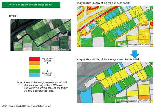
3. Activities related to geographical and terrain informationAlong with weather, geography and terrain greatly affects farming. Since the land area of Japan is small for its population, extensive areas have been developed and renovated to secure farmland. As a result, there are major variations in the geographical and terrain conditions of cropland. Some areas have been developed by reclaiming forests or wasteland, and some by draining swamps or lakes. If Japanese agriculture is to become more competitive, it is necessary to select farming methods based on the geographical and terrain conditions. NTT Geospace uses map information and satellite photos to support farmers in acquiring knowledge about geographical and terrain conditions of a particular area. The company uses four satellites to photograph a specified area with a resolution of up to 30 cm/pixel on the ground. Producers can use the photos to determine, for example, the condition of the borders of their fields in great detail. NTT Geospace has a huge archive of images (covering a land area of about 2 billion km2, which is equal to photographing the earth’s entire land area eight times). These images make it possible to study the characteristics of a specific field by comparing satellite photos of the same field taken at different times of the year, or to study the agricultural conditions of a field by combining the photos of the field with meteorological data. Furthermore, by analyzing the spectrum of satellite photos, it is possible to analyze the growth status of crops in order, for example, to forecast the growth of wheat or determine the protein content of rice grains. This will allow visualization of the optimal harvest time or a stable supply of tasty farm products (Fig. 2).
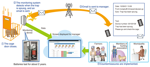
4. Activities related to preventing wild animal damageWild animals can also seriously affect agricultural production. In recent years, losses caused by wild animal damage to farm products have been on the order of 20 billion yen annually. Deer and wild boar are the chief culprits. To cope with this situation, damage prevention programs are developed in accordance with the Law Concerning Special Measures for Prevention of Wild Animal Damage. These programs involve community-wide efforts to catch the animals causing the damage [2]. One problem with catching animals is the tremendous workload involved in repeatedly going out to inspect traps, which are usually installed in mountainous areas. NTT PC Communications has been working to solve this problem and has developed a trap monitoring system called Mimawari-Rakutaro that combines M2M (machine to machine) technology, a network, and a cloud. The system has proven to be highly effective. It works as follows. The monitoring device detects when a trap has been sprung and sends an email to the manager of the trap. Since traps are usually installed in areas away from residential areas, it is difficult to supply power to monitoring devices. To avoid this problem, Mimawari-Rakutaro is powered by batteries, which can last for about two years without replacement (Fig. 3).
A type of monitoring device equipped with a camera is also available. This device sends a photo when the trap on which it is installed is sprung. This makes it possible to determine whether the trap has been sprung in error. The system has been sold since July 2011. Today, about 300 systems have been installed in 40 municipalities around the country, helping to reduce wild animal damage to agricultural products. 5. Future planIn addition to the solutions introduced in this article, the NTT Group provides an extensive portfolio of agricultural solutions applicable to different stages of the value chain of agriculture, from production to distribution and sales. We plan to gradually join them together in an organic manner so that the integrated solutions will run through the entire value chain, enabling us to provide solutions with greater added value. References
|
|||||


