 |
|||
|
|
|||
|
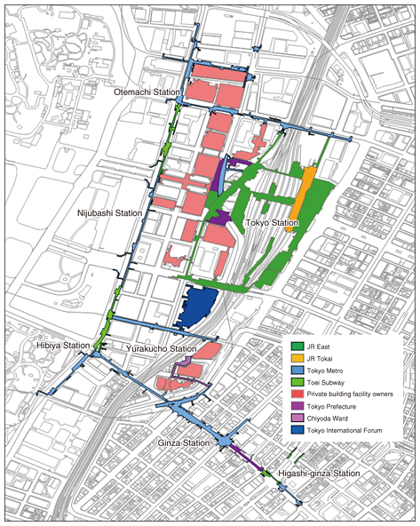
Feature Articles: NTT Group Activities in the Transportation Field Vol. 14, No. 7, pp. 12–17, July 2016. https://doi.org/10.53829/ntr201607fa3 Seamless Indoor/Outdoor Navigation Feasibility Test near Tokyo Station—Part of the High-Accuracy Positioning Society Project Sponsored by the Ministry of Land, Infrastructure, Transport and TourismAbstractOutdoor positioning accuracy will improve when full-fledged operation of the quasi-zenith satellite system starts in 2018. This, together with advances in indoor positioning technology, is expected to usher in a high-accuracy positioning society, in which high-accuracy location information can be used seamlessly both indoors and outdoors. This article introduces the Seamless Indoor/Outdoor Navigation Feasibility Test near Tokyo Station, conducted as part of the High-Accuracy Positioning Society Project sponsored by the Ministry of Land, Infrastructure, Transport and Tourism. Keywords: geospace, high-accuracy positioning society, seamless indoor/outdoor positioning  1. IntroductionFull-fledged operation of four quasi-zenith satellites will start in 2018. This will dramatically enhance the high-accuracy positioning environment, providing opportunities to create new services across a wide range of fields, including disaster prevention, transportation, and agriculture, as we approach 2020. Activities have been carried out in the past to improve positioning accuracy in indoor areas, where positioning satellites are ineffective. However, various obstacles have stood in the way of building positioning environments that can be used in a wide variety of areas. Since many people spend much of their time indoors in places such as underground shopping arcades, other commercial facilities, and office buildings, a positioning environment that can seamlessly work both indoors and outdoors is desirable. Establishment of such environments will give rise to a variety of location information-based services. It will also provide convenience, safety, and security for tourists and international visitors, and help to resolve social issues related to indoor spaces. The National Land Information Division, which is part of the National and Regional Policy Bureau in the Ministry of Land, Infrastructure, Transport and Tourism, is undertaking the High-Accuracy Positioning Society Project with a view to building a world-leading environment that will facilitate the creation of services that utilize indoor/outdoor positioning technologies. This article introduces the Seamless Indoor/Outdoor Navigation Feasibility Test near Tokyo Station, which was conducted as part of this project in fiscal 2015. The test is focused on developing a seamless indoor/outdoor digital map, constructing a positioning environment, developing a navigation application that uses this environment, and implementing service ideas that have emerged. 2. Overview of feasibility testIn fiscal 2014, a number of enterprises participated in the High-Accuracy Positioning Society Project, in which an experiment was carried out to evaluate the accuracy and effectiveness of various positioning methods in a small area near Tokyo Station. Based on the results of that experiment, a larger-scale feasibility test was conducted for a period of about one month (February 4 through March 6, 2016) in a larger area (encompassing the Otemachi, Marunouchi, Yurakucho, Yaesu, and Ginza districts) that is criss-crossed by underground passageways near Tokyo Station (Fig. 1). A trial navigation service was provided in this test, using an application called Japan Smart Navi. In preparation for this trial, a digital indoor map of the area was developed, and an environment for an indoor positioning service was built by installing indoor positioning devices. In parallel with the trial, activities were carried out to expand the use of location information services that would work in this seamless indoor/outdoor positioning environment. Those activities included feasibility tests of various applications provided by companies that have business ideas, and an ideathon/hackathon that was conducted to encourage the generation of ideas on location information-assisted applications that would enhance the appeal of Tokyo Station.
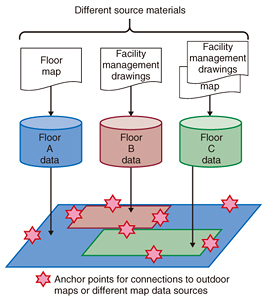
2.1 Objectives of feasibility testThe objectives of the feasibility test were to identify new technical and operational issues by extending the trial area from a limited area to a wider area covering an extensive network of underground shopping arcades, and to develop a model business operation that could be emulated elsewhere. The environment for a location information-based service was constructed at low cost using off-the-shelf technologies based on the reasoning that the positioning accuracy only needed to be adequate for pedestrian navigation. This would make it financially possible for organizations elsewhere to construct similar environments. All of the preparatory work for the feasibility test was studied and recorded, including both operational procedures—such as obtaining facility drawings, negotiating with owners of buildings and underground shopping arcades regarding installation of positioning devices, and applying to government offices for permission to use underground and other spaces—and technical procedures such as studying optimal locations for beacons and developing an integrated indoor map. 2.2 Feasibility test environment(1) Digital indoor map It was decided to efficiently develop an integrated digital indoor map by using existing maps and measurement records as much as possible instead of initiating a new survey, considering that the map only had to be adequate for pedestrian navigation. Key considerations in developing the digital map were as follows: • NTT GEOSPACE’s “GEOSPACE” map, which includes corrections to the reference map, was used as the reference outdoor map. • Existing mobile mapping system data were also used at the connection points between indoor and outdoor maps. • Location information codes were assigned to anchor points at which indoor and outdoor maps had to be interconnected seamlessly. • The map was developed so as to conform to the draft map specifications being studied by the Geospatial Information Authority of Japan. For indoor spaces in buildings and underground shopping arcades, floor plans and facility drawings held by respective facility owners were collected. Anchor points were specified at interconnections between indoor and outdoor areas and at entrances to buildings and underground pathways (Fig. 2). To develop a single map from multiple drawings, it was necessary to connect different drawings seamlessly. Therefore, the bulk of the map development work involved making adjustments at interconnection points between different drawings and between indoor drawings and outdoor maps. Since our target map was to be made public, we had to extract from facility drawings those areas where pedestrians would pass through. These facility drawings were essential in developing a precise digital map, so care was taken to collect them efficiently and securely.
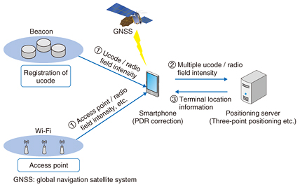
(2) Positioning environment We planned and constructed the positioning environment in such a way that it would best support pedestrian navigation. The main considerations in planning the environment were as follows: • Inexpensive beacons for transmitting positioning signals were installed. We utilized NTT DATA’s know-how gained through its BeaconNAVI. • Beacons were installed at high density in some areas and low density in other areas, depending on the availability of existing Wi-Fi signals. • A location information code based on ucode was transmitted so that the location could be identified without having to send an inquiry to a server. • Pedestrian dead reckoning (PDR) was used as a means of positioning that did not depend on signals. BeaconNAVI is a mechanism in which the installation of beacons at 10 m intervals enables a positioning resolution of 3 m and enables the switching of floors (i.e., selection of floors) in a commercial facility with an atrium. We installed the bare minimum number of beacons to provide a positioning resolution that was adequate for pedestrian navigation. Some 300 beacons, most of them battery powered, were installed. We had to install solar-powered beacons, which do not require frequent maintenance, in some areas where it was necessary to reduce the workload of replacing batteries. (3) Feasibility test system and application We provided a navigation service using Japan Smart Navi, a prototype application that used the established positioning environment and map, in the hope that many people would appreciate the convenience of seamless indoor/outdoor navigation. The configuration of the feasibility test system is shown in Fig. 3.
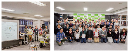
• Positioning module: This module obtained information about beacons and Wi-Fi access points from the server. If it could not receive any positioning signals, it used PDR to calculate the best location estimate using a number of positioning methods. • Map information display: Map information was displayed for each floor (story). The map was scrolled, and the floors were switched based on location information. We provided information about points of interest (POIs) including public areas—such as ticket gates at stations, exits at the ground level, and restrooms—and private-sector POIs such as restaurants, information for which was managed by NTT Resonant, the provider of the “goo!” portal site. The main functions of the application are: • Searching for a particular place, focusing on POIs near Tokyo Station • Search for a route that indicates the optimal route to the destination or a route with fewer barriers • Displaying the current location, provided seamlessly whether indoors or outdoors In addition to the application provided by the feasibility test organizer, the positioning environment and the map were provided independently in order to encourage creation of services by third parties. We collaborated with four enterprises/organizations to test their applications, which were aimed at supporting stress-free mobility, providing safe evacuation guidance in times of emergency, or enhancing positioning accuracy. 3. Ideathon and hackathonWe surmised that the availability of the positioning environment and the indoor map would encourage the creation of new services, so we conducted an ideathon on December 13, 2015 and a hackathon on January 23–24, 2016 entitled Ideathon/Hackathon to Enhance the Appeal of Tokyo Station (Fig. 4). These events were coordinated by Associate Professor Naohiko Kohtake of the Graduate School of System Design and Management at Keio University.
The participants were highly motivated since these events concerned the area around Tokyo Station, which has symbolic significance. Consequently, 11 service ideas were presented in the ideathon. It was confirmed that in addition to services proposed by enterprises/organizations, efforts to invite members of the general public to propose service ideas were effective for creating a variety of location information-based services. In the hackathon, six teams developed service prototypes based on the service ideas presented in the ideathon within a limited period. To enable quick development, we helped by providing positioning modules and map information, and organizing a support team that assisted the contestants in data collection and service development. As a result, innovative and/or highly feasible services were developed such as a tour guide around Tokyo Station using bots (software agents) and mission-clear type information collection associated with location information. Thus, the establishment of a seamless indoor/outdoor positioning environment and map led to the creation of a range of services. 4. Future prospectsJapan has a number of terminal stations with large underground spaces for pathways and commercial activities. Establishing a seamless indoor positioning environment and map in such places will enable the creation of new, world-leading services. To expand the number of indoor areas where positioning environments are available, it is necessary to solve both operational issues—such as how to efficiently collect facility design drawings for producing an indoor map and how to reduce the workload of installing and maintaining positioning devices—and technical issues such as how to produce a seamless map and how to improve indoor positioning accuracy. Improvement in positioning accuracy is expected to lead to the development of barrier-free applications and to facilitate risk management and infrastructure management. Combining positioning capability with information and communication technology will stimulate development of real-time information services with high added value that will work with digital signage units that are associated with location information. It will also make it possible to analyze the data of collected location-related information in order to resolve congestion at event sites or provide smooth evacuation guidance during emergencies. As we approach 2020, high-accuracy positioning is expected to improve services across a wide range of fields such as improving convenience for tourists and international visitors, and assisting in transportation planning and personnel distribution planning. Reference
|
|||