 |
|||||||||||||||
|
|
|||||||||||||||
|
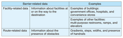
Feature Articles: NTT Group Activities in the Transportation Field Vol. 14, No. 7, pp. 25–30, July 2016. https://doi.org/10.53829/ntr201607fa5 Technology for Social Development of Accessibility MapsAbstractAt NTT Service Evolution Laboratories, we are developing technology for creating information needed to support the mobility of elderly persons and the disabled. It consists of a crowd sensing function, which determines road gradients using a smartphone equipped with GPS (Global Positioning System) and an accelerometer, and technology for collecting information needed to support pedestrian mobility, which assists surveyors with no specialized knowledge. The objective is to achieve the capability to both collect and update information at low cost. Keywords: accessibility map, pedestrian mobility support, pedestrian network  1. IntroductionWith the accelerated aging of Japanese society, there is an urgent need to reinforce accessibility measures in order to support the elderly and persons with disabilities. Accessibility legislation (the Act for Promoting Easily Accessible Public Transportation and Facilities for the Aged and the Disabled) took effect on December 20, 2006. This has prompted efforts to make facilities—starting with train stations and public facilities—accessible according to guidelines formulated by individual municipalities. Along with these efforts, municipalities, social welfare councils, and volunteer organizations are collaborating to create accessibility maps that provide information about surface conditions, road widths, and the presence of barriers such as curbs along streets, bumps on roads, and steps on sidewalks in key districts designated by municipalities, and to provide information about the availability of multi-purpose restrooms, ramps, and elevators in public facilities. To ascertain actual needs, we interviewed persons with disabilities and the organizations that support them, and we identified three major requirements. First, persons with mobility issues want reliable information about places that they would visit only occasionally, rather than those that they frequent in the course of everyday living. Second, they want information about not only public facilities but also facilities that help them to enjoy life. Third, persons with mobility issues use various ways of getting around such as walking unaided, walking with the aid of canes or walkers, and riding in regular and electric wheelchairs, and they want to know about routes that are suitable for each of those means. This article focuses on the third requirement and discusses how to collect and update data that are relevant for different means of mobility. 2. Regional efforts to gather and utilize dataMany communities have implemented initiatives in which a large number of citizens cooperate to collect accessibility information for a wide area, rather than just for selected areas. One internationally recognized activity is Wheelmap [1] run by Sozialhelden e.V., a nonprofit organization (NPO) in Germany. In Wheelmap, surveyors, called mappers, enter information about the wheelchair compatibility of each facility on OpenStreetMap [2]. There are many other initiatives being undertaken by states or municipalities. Omuta City in Fukuoka Prefecture has gathered and compiled information about the accessibility statuses of some 20 km of roads and 22 facilities along tourist routes, including the city’s downtown area and facilities related to the historic Miike Coal Mine, which has been listed as a United Nations World Cultural Heritage site, in order to be ready to welcome tourists [3]. Matsue City in Shimane Prefecture has integrated public facility data managed by the Shimane Prefecture government, accessibility data owned by a local NPO, and facility data managed by the Matsue City government in order to provide data required by a pedestrian mobility support service. The city is working with Shimane University and local information technology enterprises in order to provide and utilize this information as open data [3]. Kamakura City in Kanagawa Prefecture has added information collected by a local NPO and volunteers on the availability of multi-purpose restrooms and ramps to the basic information about its shared facilities. Five municipalities on the Miura Peninsula (Yokosuka, Hayama, Kamakura, Zushi, and Miura) are promoting the provision of accessibility information as open data. Three cities in the region (Kamakura, Yokosuka, and Yokohama) are holding joint hackathons [3]. 3. Identifying issues and setting goalsAs of April 1, 2013, Japan had more than 1.2 million km of roads, including those managed by the state and those controlled by municipalities [4]. Clearly it would cost an enormous amount of money to collect and update information about all of these roads every year, and several issues would need to be addressed. First, it is important to reduce the cost of data collection and updating. One solution would be to invite citizens to participate in surveys. While this would make it possible to survey wide areas, it would be difficult to ensure that the collected information conforms to standard criteria because members of the public do not have specialized knowledge. Consequently, one issue is how to collect standardized information. Next, it is necessary to identify what types of information must be collected. To provide reliable accessibility information about a route, it is necessary to have information about facilities at or en route to the destination and information about the streets and pathways regarding the existence of hills or steps (Table 1). Then it is necessary to develop accessibility information about routes and destinations by overlaying the collected information on the logical road data, which is known as network data. Finally, additional information is needed in order to present the network data to users. For example, if network data are to be presented on a map, map data are required. If the direction in which the user should progress is to be indicated, information about the user’s current position is required.
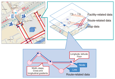
In 2010, the Ministry of Land, Infrastructure, Transport and Tourism released Draft Specifications for Pedestrian Network Data [5]. It defined a data structure for developing information about a network that consists of nodes and links to indicate whether or not they are usable by pedestrians, and for overlaying a variety of information about pathways and facilities on the network (Fig. 1). However, pedestrian network data involve such detailed definitions that they can only be developed by specialists in survey technology. Such surveying also tends to be costly, at 100,000 yen/km [6].
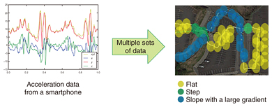
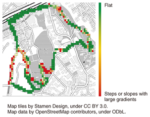
To reduce this cost, we are seeking to present standards for data entry to surveyors in an easy-to-understand manner, avoiding extreme precision but still conforming to the pedestrian network data specifications. This would enable even non-specialist surveyors to collect information for use in pedestrian network data. An important issue here is how to ensure that the collected data are sufficiently precise for practical purposes. 4. Technology for generating information needed to support pedestrian mobility: MaPieceWe are developing MaPiece, a technology for generating information needed to support pedestrian mobility, with a view to reducing costs for information generation and updating, while retaining sufficient data precision for supporting pedestrian mobility. This technology consists of two technical elements. 4.1 Crowd sensing technologyThe first element is crowd sensing technology. This determines if a particular road is flat enough for wheelchairs using data from sensors such as accelerometers, Global Positioning System (GPS), and barometers, which are built into a smartphone. This technology detects barriers to wheelchairs (steps or slopes with gradients greater than five degrees) and selects routes that are flat enough for wheelchair use. Most smartphones have GPS and accelerometers. A smartphone application that implements this technology collects GPS and sensor information for each step to be taken by the surveying pedestrian. Machine learning is used to determine from the collected data whether the road surface is flat or has steps or slopes with steep gradients. This information is combined with GPS information and overlaid on a map. A survey by a single pedestrian may not be sufficiently accurate or could involve GPS information errors. Therefore, we combine the survey results of many pedestrians to reduce the effects of errors and determine which roads are flat enough for wheelchair use (Fig. 2). However, other types of information cannot be surveyed using sensors in smartphones, for example, road width and availability of multi-purpose restrooms, elevators, and parking spaces for vehicles carrying persons with disabilities.
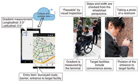
The extent of GPS error depends on the GPS measurement environment, for example, whether it is indoors or outdoors. In particular, the extent of error is greatly affected by the presence of a shielding object if GPS/GNSS* is used. Thus, this technology works best when used in an outdoor area that is free of shielding objects. 4.2 Technology for collecting information needed to support pedestrian mobilityThe second technical element is aimed at enabling persons with no specialized knowledge to use tablets to collect information needed to support pedestrian mobility. Paper is most often used in surveys for collecting information needed to generate accessibility maps. In contrast, this technology makes the most of tablets. Existing information and information about the objects to be surveyed are stored in advance and displayed on the tablet during surveying so that the surveyor does not need to enter such information. Upon completion of a survey, information collected by individuals is gathered via a communication network. When a surveyor detects a barrier or a certain type of facility, he/she can select the appropriate entry item on the map and enter, for example, the gradient of a slope measured by a built-in sensor, or take a photo of the particular site (Fig. 3).
5. Experiment and evaluationTo evaluate this technology, we carried out an experiment in the Yamate district and four other areas in Naka-ku, Yokohama City, Kanagawa Prefecture, in November-December 2015. 5.1 Experiment on crowd sensing technologyWe evaluated how accurately this technology could determine road surface conditions (flat or the presence of steps or slopes with steep gradients) and select flat roads in a field trial. A total of 72 surveyors participated in the experiment. They carried smartphones with built-in sensors and walked along designated roads with different surfaces. The smartphones were carried in different places (pockets or bags) and at different angles. Some examples of the experimental results are shown in Fig. 4.
The measured data were compared with correct data. It was found that flat roads were identified with an accuracy of 70% or higher. 5.2 Experiment on technology for collecting information needed to support pedestrian mobilityWe developed an application that runs on tablets. To evaluate the efficiency and accuracy of data collection, we asked surveyors without specialized knowledge in land measurement or on the information to be collected to participate in this experiment. This experiment involved two different surveys: 1) Survey 1: This survey was conducted by a team comprising one person in a wheelchair and two able-bodied persons, all of whom were well versed in the application and the information to be collected. 2) Survey 2: This survey was conducted by a team comprising one person in a wheelchair and two able-bodied persons, none of whom had specialized knowledge on the application or the information to be collected. Members of each team shared, as appropriate, the tasks of determining problematic areas on sidewalks, measuring widths and gradients, and entering data in a tablet. In each of the five districts, Survey 1 was conducted once, and Survey 2 was conducted six times. Survey 1 recorded an accuracy of 97% or higher, and the survey cost was less than one-tenth the cost of conducting measurements with specialist surveyors. The accuracy of Survey 2 was somewhat lower than that of Survey 1. This result enabled us to identify issues regarding instructions to be given to surveyors and issues to be addressed to improve the application. 6. Future prospectsThe above experiments have given us confidence that information about pedestrian routes can be collected at low cost without sacrificing accuracy. We are now improving the crowd sensing technology to raise the accuracy of identifying flat roads and also to enhance the functionality and operability of the technology for collecting the information needed to support pedestrian mobility. Our future plans include extending the current technology to cover indoor areas by combining it with the seamless navigation information management platform technology, conducting a study on a full-fledged pedestrian mobility support smartphone application, combining the collected information with information about roads on which wheelchairs have actually traveled successfully, and developing technology that supports pedestrians with visual impairments. References
|
|||||||||||||||