 |
|||||||||||||
|
|
|||||||||||||
|
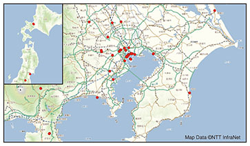
Feature Articles: 2021 International Sporting Event and NTT R&D—Technologies for Making the Event Inclusive Vol. 20, No. 2, pp. 60–67, Feb. 2022. https://doi.org/10.53829/ntr202202fa8 Barrier-free Route Guidance × MaPiece®AbstractNTT developed Japan Walk Guide, a barrier-free route-guidance application for wheelchair users and other people with limited mobility. Japan Walk Guide provides one-stop barrier-free route information, ranging from public transportation to walking routes, mainly based on barrier-free information collected by volunteers. This article discusses an evaluation by wheelchair users of Japan Walk Guide launched during the international sporting event held in Japan in 2021. Keywords: barrier-free, mobility support, walking-space network  1. OverviewWe want wheelchair users to be able to move around freely and enjoy watching sports. About 1900 volunteers gathered under the auspices of the All Japan Business Committee to collect barrier-free information with the aim of creating a society in which everyone can live comfortably without barriers. The information was collected over a wide area of Japan, from Sapporo, Hokkaido Prefecture in northern Japan, to Izu, Shizuoka Prefecture in central Japan, and covered 41 sports stadiums, including the Japan National Stadium (Fig. 1), and 98 stations nearest those venues. NTT has been supporting the collection of barrier-free information not only from volunteers but also from a technical standpoint by providing MaPiece®, a barrier-free information and communication technology developed by NTT laboratories.
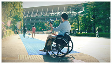
The 2021 international sporting event held in Japan drew worldwide attention to barrier-free initiatives. Through this event, NTT aimed to further expand the culture of a cooperative society through citizen participation by promoting the efforts of volunteers to collect barrier-free information. To aid our efforts, we developed a barrier-free route-guidance service for wheelchair users, called Japan Walk Guide, covering the Japan National Stadium and other sports venues. Barrier-free information used in this service was collected by the All Japan Business Committee and Ministry of Land, Infrastructure, Transport and Tourism. Japan Walk Guide was released by the All Japan Business Committee for spectators and officials watching the event from July 13, 2021 until September 5, 2021, when the target event ended. A photograph of a wheelchair user using the app is shown in Fig. 2.
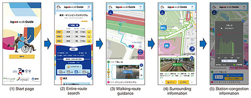
2. Japan Walk Guide2.1 Service design of Japan Walk GuideWhen we interviewed wheelchair users when we were designing Japan Walk Guide, we found that they all felt anxious about whether they could get to event sites by public transportation and had to looked up a great deal of information before going out. Responding to concerns such as “Is there an elevator at the station I use?”, “Is the road from the station to the venue flat?”, and “Is there a wheelchair-accessible restroom at the station or along the walking route?”, wheelchair users must meticulously check various services, such as websites of event organizers and transportation companies, map apps, and street-photo provision sites, which has been a barrier to wheelchair users. Accordingly, Japan Walk Guide was designed as a service providing necessary information—such as public transport-transfer information from the station closest to the departure point to the station closest to the venue, information on barrier-free walking routes from the station closest to the venue to the venue, and information on surrounding facilities that can be used by wheelchair users such as multi-functional toilets and rest areas, in a one-stop manner. Considering the concept that we want people to enjoy going out without anxiety, we adopted a graphical design that creates a sense of enjoyment while being creative in the use of colors and illustrations in the design of the screen (see Fig. 3 “(1) Start page” for a screenshot of the key design).
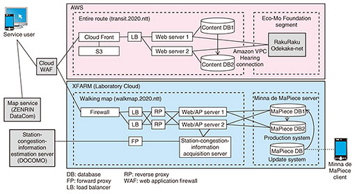
Following the postponement of the target sporting event due to the novel coronavirus (COVID-19) pandemic, we conducted more interviews with wheelchair users to investigate any change in their sense of values concerning their mobility as a result of the pandemic. We learned that wheelchair users have always tried to avoid congestion; however, during the pandemic, their need to avoid congestion has become even stronger. With that result in mind, we added a function to Japan Walk Guide that provides information on station congestion so that wheelchair users can move around with peace of mind by using stations when they are less crowded. 2.2 Details of Japan Walk GuideImplemented as a web application, Japan Walk Guide can be used instantly by following a URL (uniform resource locator) link that is read via a QR code without the need to install a native application. It was implemented in this manner because attendees at sporting events would probably not use a dedicated app because of the high psychological barrier of installing it just for a short-lived event. As a responsive service, the app can be used to either gather information in advance on a personal computer at home or check information on a smartphone while on the move. The details of each function of the app, along with screen transitions when using the app, are described below. (1) Entire-route search considering barrier-free walking routes Clicking the Start button on the start screen takes the user to the search screen that includes public transportation for the entire route. The search for transfers on public transportation is linked with the “RakuRaku Odekake-net” (supported by the Nippon Foundation) provided by the Foundation for Promoting Personal Mobility and Ecological Transportation (Eco-Mo Foundation). The RakuRaku Odekake-net is a service that provides barrier-free information (such as barrier-free facilities in stations and transfer information) for the elderly and disabled in an integrated manner. It is operated by the Eco-Mo Foundation and uses information about barrier-free transportation collected from transportation operators and facility managers throughout Japan [1]. (2) Walking-route guidance In addition to the public-transportation route search described in (1) above, the app also displays barrier-free route information covering the walking section from the station to the target stadium. This function allows the user to (i) specify the target stadium as the destination or departure point and (ii) search the entire route in consideration of barrier-free information for the walking route (Fig. 3(2)). The barrier-free route is based on the “Transportation Plan V2” [2] (published by the Bureau of Olympic and Paralympic Games Tokyo 2020 Preparation of the Tokyo Metropolitan Government) combined with barrier-free information collected by volunteers from the All Japan Business Committee. As well as showing the barrier-free route, it provides information about the route (such as slopes and steps) along with photos of the area collected by volunteers from the Committee. With this information, users can confirm in advance whether the route is passable in accordance with the degree of their disability (Fig. 3(3)). (3) Information about the surroundings Clicking the Surroundings map button on the walking-route guidance screen switches to the surrounding information screen. In addition to viewing information about the route between the venue and nearest station, the user can also refer to information about nearby wheelchair-friendly facilities such as multi-functional toilets, information centers, and rest areas. At the same time, the surrounding walkways are displayed in three different colors (green, yellow, and red) in ascending degree of barrier to mobility. By clicking on a particular walkway, the user then can confirm its slope and width displayed in conjunction with photographs of the walkway. If the user wants to go to a facility that is in the vicinity but off the route between the venue and nearest station, they can check the best route that matches their particular disability characteristics. The app also has a function that allows users to correct errors in the barrier-free information. If the user finds an error in the barrier-free information, they can report it using the “○” or “×” button and request a volunteer to correct the information (Fig. 3(4)). Thanks to the cooperation of users and volunteers, it became possible to update the information during the service period, thereby creating a more-accurate barrier-free map. (4) Information about congestion at stations Wheelchair users find it difficult to move around a station and board a train when the station is crowded. As mentioned above, the COVID-19 pandemic has further strengthened the need to avoid congestion. For wheelchair users to be able to go out without anxiety, we added a function that displays information about expected congestion at the station nearest the venue so that wheelchair users can avoid congested areas (Fig. 3(5)). The station-congestion information is provided through cooperation with railway companies (namely, Tokyo Metro, East Japan Railway, and Tokyo Waterfront Area Rapid Transit) by linking with station-congestion prediction technology (developed by NTT DOCOMO), which uses artificial intelligence and demographic information based on cell-phone base-station operation information. By modeling the relationship among the estimated number of passengers at a station during past events and the population-distribution data and weather data at that time, this technology can predict the number of passengers at a station at 10-minute intervals into the future (for up to 90 minutes) from the most-recent population distribution, weather, and event-schedule data. The population-distribution data are estimated using a service called Mobile Spatial Statistics® Domestic Population Distribution Statistics (real-time version) [3]. Since this service can obtain past (one hour ago at latest) population-distribution data, it is possible to reflect the latest congestion situation and predict congestion with high accuracy [4]. 2.3 System configurationThe system configuration of Japan Walk Guide is shown in Fig. 4. The app is composed of two units: (i) an entire route unit that provides public-transportation transfer information and (ii) a walking map unit that provides barrier-free information for walking routes. The transfer information is generated using the application programming interface (API) of RakuRaku Odekake-net [1]. Due to the security requirements of RakuRaku Odekake-net, it is necessary to use an Amazon Virtual Private Cloud (VPC) peering connection, so we built the entire-route unit on an Amazon Web Services (AWS) platform.
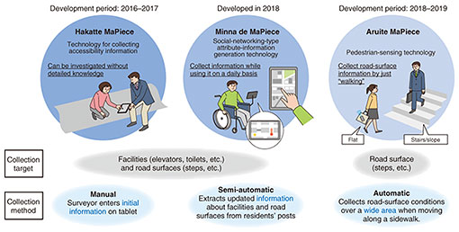
The walking routes were provided by combining the official accessible routes (official routes for people with limited mobility) to the venues described in the Transportation Plan V2 (published by the Bureau of Olympic and Paralympic Games Tokyo 2020 Preparation of the Tokyo Metropolitan Government) and barrier-free information collected by the All Japan Business Committee. The barrier-free information was created using Minna de MaPiece as a base/platform engine and superimposing it on the map service. ZENRIN DataCom’s “Itsumo NAVI API/SDK” [5] was used as the map service. The walking-map unit was built on XFARM, a cloud environment of NTT laboratories. 3. Barrier-free information and communication technology MaPiece®To support people with limited mobility, such as the disabled and elderly, it is important to prepare barrier-free information for navigation that provides users with routes that can be taken without fail, in addition to the development of hardware such as barrier-free facilities. In the past, municipalities commissioned experts with surveying skills to create barrier-free information on the basis of their standards. Due to the high cost of surveying, however, it was difficult to create and update the survey data frequently. Moreover, the standards differed from municipality to municipality, so it was difficult to use data across the board. To address these issues, MaPiece® was developed to enable volunteers who do not have map-making expertise to collect barrier-free information for highly accurate navigation in accordance with the Specification for Spatial Network Model for Pedestrians formulated by the Ministry of Land, Infrastructure, Transport and Tourism [6]. To enable sustainable collection and update of barrier-free information, MaPiece® is configured as three sub-technologies: (i) Hakatte MaPiece, a field-survey tool for collecting initial information; (ii) Minna de MaPiece, which collects corrected and updated information from users when they use the service and updates the information in a social-networking manner; and (iii) Aruite MaPiece, which automatically collects road-surface information from pedestrians’ smartphone sensor data by using cloud-sensing technology (Fig. 5).
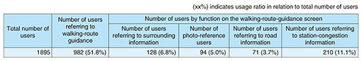
The barrier-free information collected by volunteers using Hakatte MaPiece and Aruite MaPiece is imported for Minna de MaPiece, and through the API of Minna de MaPiece, the information from users is retrieved and reflected in the latest posted information. The updated data are compliant with the Specification for Spatial Network Model for Pedestrians and can be used for other barrier-free information services even after the Japan Walk Guide service ends. 4. ResultsTable 1 lists the number of users of Japan Walk Guide from July 13, 2021 to September 5, 2021. In 2021, the international sporting event was held in Japan without spectators, and Japan Walk Guide was used by volunteer staff with impaired mobility.
Through a questionnaire and interviews, we also evaluated the experiences of five wheelchair users during the event. All five respondents answered that they would use Japan Walk Guide for finding out how to get to event sites compared with current guiding current services. Each user gave a different reason. Comments such as “road conditions to the venue are displayed accurately,” “the train-information function is convenient,” “various barrier information such as the slope of the walkway is posted,” and “information on wheelchair-accessible toilets is useful” demonstrated the usefulness of providing information via Japan Walk Guide in conjunction with the above-mentioned information on slopes and steps based on standards provided by the Ministry of Land, Infrastructure, Transport and Tourism in a one-stop manner. The majority of the respondents felt that the congestion information was necessary; in particular, four out of five answered that it was “necessary” or “better to have than not,” indicating that the information was generally useful. Regarding a comparison of the usage rates by function, the usage rate of station-congestion information was the highest among the users who referred to the walking-route guidance screen (Table 1). However, because the target event was held without spectators, cases of congestion at stations did not occur, so we were unable to evaluate the actual effect of the station-congestion information. 5. Concluding remarksDue to the fact that many of the venues were not open to the public, only those involved in the event were able to use our service, and the general public was not able to experience it. Even so, the release of Japan Walk Guide at a sporting event that drew worldwide attention to barrier-free initiatives in the domestic and international press. For example, it was featured in Taiwanese web media as one of ten friendly actions that supported athletes in the “spirit of inclusion.” We believe that our efforts were significant from two aspects: (i) raising awareness of the fact that ordinary people can collect barrier-free information and create barrier-free maps themselves and (ii) fostering a culture of continuously updating barrier-free maps. The barrier-free information collected by the All Japan Business Committee will be released as open data by the Geospatial Information Center (operated by the Association for Promotion of Infrastructure Geospatial Information Distribution). We hope that the above-described recognition will be an opportunity for the barrier-free information created by the volunteers to be used in various applications and services. In the future, we will use our efforts for the event as a first step to promote research and development of new inclusive services on the basis of the evaluation results through the provision of applications. We will also contribute to the creation of an inclusive society where people with disabilities can live independently with peace of mind. AcknowledgmentsWe thank the Public Relations Bureau, Transportation Bureau, Technology Services Bureau, and Paralympic Management Office of the Tokyo Organising Committee of the Olympic and Paralympic Games and the Ministry of Land, Infrastructure, Transport and Tourism for their cooperation and advice in the development of this application. We also thank the Barrier-Free Promotion Department of the Foundation for Promoting Personal Mobility and Ecological Transportation for their coordination of the RakuRaku Odekake-net project and the All Japan Business Committee, its participating companies, and volunteers who worked together to collect the barrier-free information and provide the application. References
|
|||||||||||||