 |
|||||||||||||||||||
|
|
|||||||||||||||||||
       |
Special Feature: NTT Technologies for the Environment and a Safe and Secure Society Vol. 6, No. 2, pp. 30–35, Feb. 2008. https://doi.org/10.53829/ntr200802sf5 Online Lightning Prediction SystemAbstractWe have been researching a system for predicting lightning about 10–30 minutes before it occurs. The system's model is based on thundercloud prediction by image processing and risk estimation by statistical processing. We tested a prototype system using the data of 2005 and the experimental results indicate that this system will be helpful for reference purposes in disaster prevention and other applications. This article outlines the concept, the prototype system, and the preliminary experimental results. 
1. Lightning damage in an IT societyIn recent years, there have been many news reports about natural disasters associated with concentrated heavy rains and thunderstorms. In addition to bodily harm and damage caused by direct lightning strikes on people and buildings, damage caused by lightning surges induced by lightning* has also become a serious issue. The cost associated with such damage has been increasing year on year as low-voltage LSIs (large-scale integrated circuits) and electrical devices connected to the network become more prevalent in the ever-expanding information technology (IT) society [1]. At the same time, power outages and voltage dips caused by lightning strikes on power substations and transmission lines may result in major damage to information-communication systems. While it is difficult to eliminate lightning damage, the ability to know that lightning is about to strike should be useful in disaster prevention, even if the warning is received only slightly before the event. Japan's earthquake early warning system, which has recently attracted attention, is a good example of how useful a little advance warning can be. That is why we are researching a system for predicting lightning.
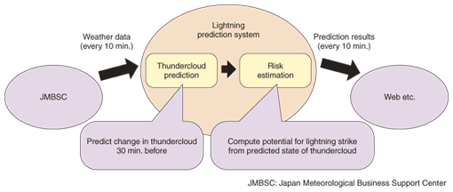
2. Classification and features of lightning prediction systemAt present, lightning prediction systems can be divided into two main methods according to their data sources. One method computes atmospheric stability by numerical weather prediction to determine whether the environment is conducive to the formation of thunderclouds. This method targets prediction in the time range from several hours to one day before. Numerical weather prediction itself uses coarse information with a 10-km mesh as its spatial scale and 3 hours as its time scale and corresponding lightning-prediction accuracy. The other method uses lightning sensors and weather radar to predict the next strike while detecting the positions of lightning in real time. Although the sensors and data-gathering systems required by this method are expensive, predictions can be made with relatively high accuracy provided that those predictions are made 10 to 20 minutes in advance. This method, however, assumes that the movement of thunderclouds can be correctly predicted. Moreover, it also depends on lightning observations, which means that it cannot predict the initial lightning strike from a certain thundercloud. In addition to the above methods, thunderclouds can be observed in three dimensions through the use of high-performance weather radar called Doppler radar, which is also used by airports for air traffic control. This observation system, however, has several limitations. It produces a large amount of data that is expensive to transmit, it cannot cover a wide area, and it is limited to the specific purpose. Thus, it cannot be considered for general use at present. We based our system on a method that does not use lightning sensors and uses only publicly available precipitation data from weather radar to make high-accuracy predictions. The system (1) predicts the lightning risk in a 1-km mesh up to 30 minutes in advance in 10-minute intervals, (2) uses only weather-radar data that can be accessed online easily and inexpensively, and (3) uses commercially available personal computers. 3. System configurationThis system consists of two parts, as shown in Fig. 1. The thundercloud prediction module predicts the formation, transition, and decline of thunderclouds up to 30 minutes in advance using image-processing technology. The risk estimation module estimates the potential for lightning strike from the state of thunderclouds using statistical processing technology. Working together, these two modules enable the system to inform users of the degree of lightning risk up to 30 minutes in advance. In this system, precipitation (cloud) observation data that forms the basis for making predictions is obtained online at 10-minute intervals from the Japan Meteorological Business Support Center. The technology used by each of these modules is outlined below.
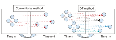
3.1 Thundercloud prediction moduleFor thundercloud prediction, we use a technique developed by NTT for predicting weather based on radar patterns called the dynamics texture (DT) method [2]. Weather radar is essentially a sensor for detecting precipitation phenomena. It senses precipitation particles in the sky from the intensity of radar reflections and visualizes the quantified intensity and extent of precipitation through a radar image. The DT method recognizes these precipitation phenomena in the form of changing image patterns and performs prediction calculations accordingly. An image consists of many pixels, and in a radar image, the color darkness of each pixel indicates the degree of precipitation. In a simple, commonly used method for predicting a radar image at time n+1 from the radar image at time n, pixels in the predicted image have a 1-to-1 correspondence with the pixels in the previous image. The DT method, however, uses a fluid dynamics model that does not necessarily result in such a 1-to-1 correspondence. Thus, neighboring pixels can be naturally blended over time (Fig. 2). This feature enables it to predict an increase or decrease in precipitation, that is, the formation, decline, and movement of a rainy area. Our system uses the DT method to predict the movement of thunderclouds—more specifically, the echo intensity (intensity of precipitation) and echo top height (maximum altitude of precipitation particles)—10, 20, and 30 minutes in advance. The DT method itself can make predictions even further in advance, but given that the lifecycle of a thundercloud is very short at about 30 minutes, this is the limit for lightning prediction.
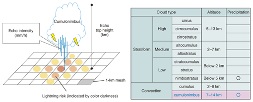
3.2 Risk estimation moduleNext, we estimate the potential for lightning strike for each 10 minutes and for each mesh cell based on the state of a thundercloud as predicted 10 to 30 minutes in advance. Our system currently targets summer lightning (heat thunderstorms) caused by cumulonimbi. The conditions under which cumulonimbi form are especially important in lightning strike prediction (Fig. 3). Cumulonimbi feature (1) intense rainfall and (2) formation in the vertical direction up to the stratosphere. The strength of each of these characteristics can be determined from the echo intensity and echo top height. We collected many past examples of lightning strikes, matched up the values of these two echo quantities recorded for each mesh cell with the number of strikes at that time, and derived a formula expressing the relationship between echo values and strike number using statistical processing such as multivariate analysis. This formula uses echo values predicted by the DT method 10 to 30 minutes in advance together with online weather radar information and estimates the possibility of lightning for each 1-km mesh cell. The base of a cumulonimbus can be several kilometers, or even several tens of kilometers across in the case of a large cloud. In addition, lightning may not necessarily strike vertically. There are many cases of lightning striking at an offset of several kilometers. Accordingly, we consider that the possibility of a lightning strike cannot be completely determined within one mesh cell but may also be influenced by neighboring cells. We therefore distribute the possibility of lightning estimated for each mesh cell smoothly over neighboring mesh cells (Fig. 3). In this system, we sum these possibilities to arrive at a final lightning risk.
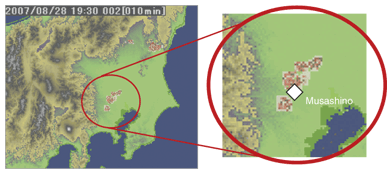
4. Prediction case study and evaluationThis section presents an example of prediction based on the two technologies introduced above. 4.1 Prediction case studyAn image of the Kanto region predicted 10 minutes in advance at 19:20 JST (Japan standard time) on August 28, 2007 is show in Fig. 4. Sections in red and black indicate locations at risk. At around that time, a voltage dip occurred at our laboratories at the NTT Musashino R&D Center (Musashino City, Tokyo). As seen from the image, the Musashino City area is in red, indicating that the risk of lightning was high.
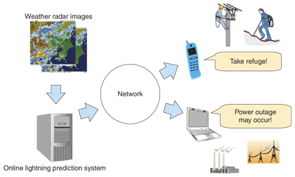
4.2 Evaluation indicator and resultsThe percentage correct is a common evaluation indicator with respect to binary prediction (in which an event either does or does not occur). However, when predicting a phenomenon like lightning that occurs rarely, a high score will be obtained by always predicting will not occur. For this reason, the critical success index (CSI) (also called the threat score) is often used as an alternative to the percentage score [3]). CSI takes a value between 0 and 1, and a higher value means higher accuracy. With CSI, a prediction of will not occur that actually corresponds to no occurrence is not an evaluation target and is not counted. As a result, CSI is considered to be a strict indicator because a high score requires the prediction of rare phenomena with pinpoint accuracy. For reference purposes, we calculated CSI for actual precipitation forecast the previous day by the Japan Meteorological Agency in 2006 from data made public on the Web [4]. Although somewhat dependent on the season and region, CSI was found to be in the range from 0.5 to 0.6. Next, for a certain hour of lightning actually observed in the Kanto region in the summer of 2005, we evaluated our system while it was making predictions 10 minutes in advance. We found that the thundercloud prediction and risk estimation modules each recorded a CSI of about 0.5 while the overall lightning prediction for both of them combined achieved a CSI of 0.3–0.4. Although this last result does not bode well for critical applications, we can expect the information provided by this system to be used empirically for reference purposes in disaster prevention and other applications. 4.3 Technical issuesOne issue to be addressed in the thundercloud prediction module is the prediction of local cloud formation and decline on a stationary front. This prediction is difficult in the DT method, so we are investigating the joint use of other mathematical models. An issue of concern in the risk estimation module is inadequate input conditions. Echo values are important elements of lightning, but it is impossible to determine whether lightning will strike solely on the basis of those elements. We therefore plan to add numerical weather prediction data as input in future versions of the system. 5. Service conceptOur research at present is focused on the computational processes required for predicting lightning, but we can envision a variety of services based on a combination of our prediction system and an information system. For example, if the prediction system is combined with a web server, it would enable ordinary users to view forecasts from a personal computer or cell phone. Likewise, the prediction system combined with a mail delivery system or cell phone location information system would enable warnings to be delivered to a user's cell phone (Fig. 5). We plan to keep such services in mind in future system development.
6. Trend toward more lightningWhile researching the system described here, we also analyzed long-term trends in the number of days with lightning per year in ten-year units. This analysis led us to believe that summer lightning in the Kanto region will increase in conjunction with future global warming. We also cannot ignore an increase in thunderstorms due to the heat island phenomenon of recent years. There will consequently be an increasing need for countermeasures against lightning damage in the years to come. 7. Future plansWe are currently working on enhancing our prediction technology for the next version of our system. In particular, we plan to apply a machine learning model such as a support vector machine (SVM) to enable a large amount of input data to be processed. Preliminary experiments have already shown that prediction accuracy can be improved in this way. This system is still at the research experimental stage, but we plan to continue our research efforts to raise accuracy and usability. References
|
||||||||||||||||||