 |
|||||
|
|
|||||
       |
Feature Articles: Activities Toward Service Incubation to Speed Up R&D of Service Systems Vol. 11, No. 9, pp. 11–15, Sept. 2013. https://doi.org/10.53829/ntr201309fa2 Wi-Fi LBS: Information Delivery Services Using Wi-Fi Access Point LocationAbstractWi-Fi location-based services (LBS) enable location-based information delivery and user monitoring for smartphone users by using Wi-Fi access point positioning data to reconfigure terminal and sensor data stored in the cloud. This article reports on Wi-Fi LBS, which includes functions for service visualization, automatic (push-type) delivery of travel information, and communication for assumed application to tourist information services.
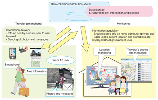
1. IntroductionThe widespread use of cell phones has enabled users to easily access content through a network while moving around outdoors. The explosive growth in the popularity of smartphones has led to a greater variety of services being implemented using the Internet and has led to proposals for various kinds of network services for users when they are outdoors. Many Internet services have been proposed that guide users to shops, tourist sites, or other places in the real world around them as the users move about. Such services belong to a new class of services called online to offline (O2O) services. We can imagine, for example, a service in which a customer can access the network inside a shop in order to obtain coupons for that shop or to use other such functions while shopping. Many services that send data to cell phones or smartphones to provide location-based information for tourism or information on traffic conditions have also been implemented. QR (quick response) codes that provide links to web services have been posted in places such as bus stops and on tourist information signs, and contactless integrated circuit (IC) card readers have been installed outdoors for operation by cell phones. Other common services introduced recently involve attaching smartphone positioning data to photos when uploading them from smartphones to sites such as social networking services (SNSs) so the user’s location can be displayed on a map provided by a map service on the SNS. When we use smartphones and other such terminals outdoors, we can also use a number of new services that are available that involve delivery of information that corresponds to the smartphone location and monitoring of the location. We have used the Wi-Fi function of smartphones to visualize information services that are based on the place in which the smartphone is located. We exhibited a class of services that we call Wi-Fi location-based services (Wi-Fi LBS) as well as one case of using visualization at NTT R&D (Research and Development) Forum 2013 as an “Information Delivery System Using Wi-Fi AP (access point) Location” [1]. This article describes the purpose of the visualization function and its configuration. 2. VisualizationWe applied the Wi-Fi LBS to an example service that provides information on tourist attractions that are near the traveler’s current location. The service also has functions for monitoring the traveler’s movements and communication between users, so we carried out visualization for those three services. To implement the visualization, we installed a special application (app) in the traveler’s smartphone and made sure it was running in advance. The main flow of the service is illustrated in Fig. 1.
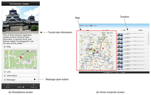
(1) Information is sent, or pushed, to the smartphone of a user who is in the vicinity of a tourist attraction, and the user is notified by a message displayed on the smartphone screen. (2) The user taps the screen to see the information. (3) The service monitors the location of the user to allow monitoring on the web from different locations. Messages can also be sent via the service to the user’s smartphone. (4) The smartphone user can upload memos and photos taken with the smartphone from the screen on which the tourist information is displayed. The uploaded data can be displayed on a map accessed by the server from the web. The monitoring function described in items (3) and (4) above enables family members at home, interested persons, and service subscribers to monitor the user’s activities. It also allows communication with the traveler. Our premise is that service scenarios that involve using the communication and monitoring functions in addition to the information delivery function in this way offer advantages to the smartphone user, family members, and service providers. 3. Objectives of visualizationThe three functions of information delivery, monitoring, and communication can be used individually or in any combination. Examples include O2O services for notifying smartphone users about nearby shops or for delivering content related to displays in museums, art galleries, etc. Services that determine the location of smartphone users can also be implemented. Wi-Fi LBS is premised on the delivery of local information to tourists as an example service that effectively uses the three functions described above. Wi-Fi LBS also uses the smartphone’s Wi-Fi function to coordinate services with the user’s location. We deliberately chose not to use contactless IC card recognition, which requires user action, so that users could receive the provided information without any conscious operation simply by going to a place. Furthermore, because problems can occur when using a global positioning system (GPS) indoors and because visualization simply needs to detect whether or not the user is at a location where the service can be provided and does not require accurate coordinates, we chose to use Wi-Fi access points placed in locations where the service can be provided instead of using GPS. The smartphone detects the access point and connects the user to the service. Wi-Fi access is now a feature of tablet devices as well as smartphones, so we expect that the use of Wi-Fi will enable the provision of services to many portable terminals. 4. Wi-Fi LBS functional configurationThe visualization function includes functions for (1) detecting the location of the smartphone, (2) delivering content to the smartphone, (3) monitoring the smartphone (terminal), and (4) communication. Detection of the location is the basis for the other functions, which provide services to the user. Each function is explained below. 4.1 Location detectionThe function for using Wi-Fi to detect locations is a key feature of our method. Currently, mainstream methods to detect the location of cell phones and smartphones use GPS to obtain device coordinates or use cloud services that provide coordinates based on information from nearby Wi-Fi access points. Our prototype service controls service functions by simply detecting when the device is near a Wi-Fi access point that is registered in a service rather than obtaining smartphone location coordinates. The detection process is performed by an app that is installed on the smartphone. The app periodically scans for Wi-Fi access points and sends data on detected access points (SSID (service set identification), MAC (media access control) address, etc.) to the service on the cloud. If the access point is registered in the service, the service returns content information (URL (uniform resource locator) etc.) to the smartphone. In this approach, the smartphone accepts delivery of information according to whether or not there is content rather than according to the location coordinates. Because the smartphone identification (ID) is sent when the smartphone sends information on the detected access points to the cloud, the service on the cloud side can determine if the smartphone is near a registered access point. Thus, location detection by this prototype service is simply a matter of determining whether or not the user is near a registered access point rather than dealing directly with location coordinates. It is therefore sufficient to directly associate content with the locations at which a service is to be provided, which makes it easy to set the content and also simplifies the management. 4.2 Content deliveryContent delivery is a basic service of this visualization for users. When the location detection function determines that the user is near a Wi-Fi access point for which there is content on the cloud, that content is delivered to the user’s smartphone. Another delivery method, called quasi-push delivery, is also available. In this method, a special app installed on the smartphones automatically displays the content. The tourist guide service assumed for visualization here, however, simply displays the message “There is a tourist attraction nearby” on the special app, and when the user taps that message on the screen, a web browser is brought up that contains the URL that was sent by the service. Because the tourist information is described in HTML (hypertext markup language) for display by the smartphone’s web browser, the content is easy to produce, and links to existing web content can also be used. The visualization function creates a screen of existing links to tourist spots in combination with the output of an Internet map service (Fig. 2(a)). The communication function that is described later in this article can also be used directly from the tourist information screen, which makes it easy to understand how the message relates to the tourist site.
4.3 Terminal monitoringThe function for monitoring the location of the smartphone user (traveler) can be used by various people, for example, by a traveler’s family members, a teacher who is leading a school trip, or other people interested in knowing where the traveler is. Another possible use is by the administrators of tourist spots who can use it to monitor the flow of visitor movements. The smartphone IDs that are sent to the service are managed on the cloud side, so it is also possible to select particular smartphones to display information. The visualization described here is mainly assumed to be used, for example, by the leader of a school field trip or by fellow travelers, so the locations of multiple travelers are displayed together. When the intended use is to monitor someone by family members at home, a display that is specific to a particular smartphone is probably desired. On the monitoring side, the location of the smartphone user on a map is displayed by a web browser on the screen of a personal computer (Fig. 2(b)). In this case, the location of the Wi-Fi access point on the map must be registered in the cloud in advance. A timeline that indicates the user’s location (tourist site) each time location data are sent is displayed to the side of the map. As the user moves, a trail of marks remains on the map to indicate the past locations of the terminal. Clicking on a mark shows who was at that location and the time the person was there. The timeline also shows this information. 4.4 CommunicationWe added the communication function to facilitate communication of information concerning the trip among the travelers on a trip, and between travelers and their families at home, because content delivery is a passive function from the viewpoint of the traveler, and the monitoring function by itself does not impede the traveler’s movements. With this service (content delivery and terminal monitoring), the smartphone user must first start up the special app. To increase the user’s motivation to start up the service when they reach a destination, we decided that it was necessary to add a function that would increase the convenience to the traveler. The communication function allows the smartphone user to attach messages and photos to the location currently displayed on their device. By touching the Write button on the web page displayed by the content delivery function, the user can upload a text message or photo taken with the smartphone. After uploading it, the message is displayed beside the point that marks the terminal location on the map and on the timeline (Fig. 2(b)). When messages for a point on the map are input on the monitoring side, the users that are near that point are notified that messages are available. Displaying messages on the map in this way serves to both encourage the exchange of location-based information and provide a record of the trip that can be displayed when the trip is over. 5. ConclusionAs an example of a Wi-Fi LBS, we have described a visualization function applied to a service for the collection and delivery of information related to specific places using the Wi-Fi function that is built into smartphones. The number of smartphone users will continue to increase, and Wi-Fi will grow as an important communication infrastructure for use outdoors as well as indoors. The visualization function that we have described is one use case of the Wi-Fi LBS class of services. For outdoor information services that use smartphones and Wi-Fi, we believe that many forms of services are possible, and that applications will expand to content delivery for ITS (intelligent transport systems) such as Wi-Fi access points set up by transportation organizations, the collection of local monitoring data with smartphones, and other services. In the future, we will continue to evaluate service visualization that offers even greater advantages and convenience to users and in which these and many other core technologies will be used. Reference
|
||||