 |
|||
|
|
|||
|
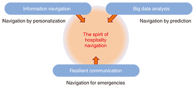
Feature Articles: The Challenge of Creating Epoch-making Services that Impress Users Vol. 13, No. 7, pp. 17–21, July 2015. https://doi.org/10.53829/ntr201507fa4 Proactive Navigation Optimized for Individual UsersAbstractIn this article, we first give an overview of the proactive navigation project that NTT Service Evolution Laboratories is striving to accomplish. Then we provide a simple explanation of the technologies currently being researched and developed to implement the project: information navigation, big data analysis, and resilient communication. Finally, we give an overview of experiments currently being run in Fukuoka City along with their results. Keywords: proactive, navigation, big data 1. IntroductionOver one million tourists visit Japan from abroad every month—a number that is projected to increase as we approach the year 2020. In fact, even domestic Japanese tourism is expected to grow in the coming years. Here at NTT Service Evolution Laboratories, we are doing our utmost to research and develop technologies—primarily for navigation—so that we can provide useful services to all of these visitors with a humble spirit of hospitality. Rather than simply trying to provide navigation instructions from point A to point B, we are considering ways to provide information that could influence a visitor’s activities (for example, suggestions for that day’s dinner plans or tourist destinations for the next day). Our ideal proactive navigation system would be able to carefully select the most useful information for a customer on the basis of his or her tastes, past activity, and plans for the day—as well as the weather—to make suggestions before the customer even has to ask for them. 2. Technological components of proactive navigationEvery customer naturally has different needs and preferences. To implement proactive navigation, we need to understand or observe customers to intuit their wishes before we can determine what to suggest and then present it so it is easy to understand. We will probably also need to understand customers’ circumstances and predict how those circumstances will change so that we can suggest the most appropriate activities for them. Furthermore, we believe that more than a few visitors from abroad will still have vivid memories of the 2011 Great East Japan Earthquake. Consequently, we feel that one of the tenets of hospitality involves providing appropriate information to visitors to ease any anxiety in the event of an emergency. We plan to address these requirements by using three technologies to implement proactive navigation: information navigation, big data analysis, and resilient communication, as shown in Fig. 1.
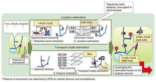
2.1 Information navigationTo provide useful information to the customer, we first need to know where the customer currently is as well as whether the customer is stationary or in transit, and, if so, what mode of transport he or she is using. We have developed two technologies to obtain this information: location estimation and transport mode estimation, as shown in Fig. 2.
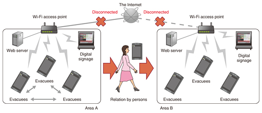
(1) Location estimation Although the Global Positioning System (GPS) allows us to very precisely pinpoint a smartphone’s current location, it still has a margin of error of 5–30 m. This has made it difficult to pinpoint a customer’s actual location while he/she is underground or in densely packed urban areas and buildings. Our location estimation technology looks at the probabilities associated with GPS measurements scattered in the temporal and spatial directions to accurately extract accumulated locations; then, using characteristics associated with various places such as stores or restaurants (for example, that a person is likely to stay in the same location for a period of 15–90 minutes to have a meal), the technology is able to improve the accuracy of a customer’s estimated location. If we are also able to measure customer locations over a longer period of time, we can expect to further improve the accuracy of our estimates by applying individual customer trends, such as stores they visited in the past. (2) Transport mode estimation Using GPS tracking, we can determine a customer’s traveling speed and thus to some extent guess that customer’s mode of transport. However, pedestrians sometimes move at the same speed as cars stuck in traffic jams in urban areas, making such guesswork more difficult. Furthermore, we would often like to distinguish between similar modes of transport such as buses and taxis. In situations like these, simple rules on the basis of whether a customer’s speed has exceeded a certain threshold are insufficient to make a decision. Our transport mode estimation technology therefore predicts patterns of movement using machine learning with the same deep neural networks as pattern recognition algorithms. This has allowed us to very precisely estimate modes of transport. With these technologies, we can provide tourist information tailored to each individual’s situation. For example, we can suggest nearby tourist spots to customers when they are likely to be finishing a meal at a restaurant, or send information on upcoming points of interest along a train route that customers are riding on. 2.2 Big data analysisAt popular tourist spots and stadiums filled with excited fans, there is a danger that a crush of crowds moving in the same direction could lead to serious accidents. Our big data analysis technology examines measurements on where people congregate in order to predict what events will transpire and when. For example, by taking measurements of crowd density distributions and extrapolating up to approximately an hour into the future, we can anticipate mass confusion before it occurs and thus suggest the appropriate actions to prevent it. However, by intervening in this way, we will also cause our original predictions—which did not account for such intervention—to become inaccurate. As a result, to keep up with actual conditions, it will be necessary to continually iterate between taking measurements, making predictions, and suggesting actions in real time. We are currently pursuing research and development (R&D) efforts to effectively accomplish this processing loop in real time. Our R&D efforts also encompass the technological building blocks for making suggestions that meet each individual customer’s needs by intimately understanding the customer’s point of view and even considering factors that he or she has not consciously noticed. So far we have established technologies for recommending routes to tourists (e.g., from point A to B to C); technologies for determining whether a visitor’s trip is routine or unusual on the basis of an analysis of the trip’s time of day, day of the week, and location; and technologies for analyzing multidimensional composite data to determine when and where it would be easy for someone with particular attributes to easily visit. These technologies allow us to provide fine-grained navigation appropriate for individual customer circumstances. 2.3 Resilient communicationBecause Japan is a country where natural disasters occur frequently, we feel that our navigation system must convey a sense of security that it will get a customer to safety whenever and wherever disaster strikes. It is now common for many ICT (information and communication technology) services to assume that client devices are always connected to the cloud. However, power and Internet connections can be cut off in the event of a disaster, preventing people from using cloud-based services. In situations such as these, our resilient communication technology allows end-user devices to communicate with each other using only Wi-Fi and an HTML5* -compliant browser—even without a dedicated application—as shown in Fig. 3. Furthermore, our implementation will allow devices to be carried between disconnected Wi-Fi service areas to relay information back and forth and make continued communication possible.
Next we plan to target facilities of local municipalities that are expected to be used as evacuation centers in times of emergency. Our goal is to use only the equipment available at these evacuation centers to implement a communication system that provides the essential function of checking on the safety of evacuees as well as a system that can be used to build infrastructure for supplying information. In 2015, we are planning to conduct a trial of application services that can achieve the minimum level of individual safety reporting when evacuation centers lose power and network connections. Following the trials, we will work to address any issues that arose.
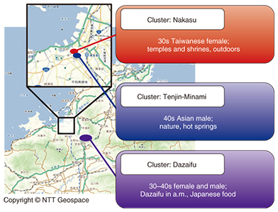
3. Examples of current workHere, we introduce a regional revitalization trial that has been ongoing in Fukuoka City since October 2014, involving tourism services for visitors from abroad. The trial’s primary participants are the JTB Group, a leading travel agency in Japan, and the NTT Group. During the trial, we provided both foreign and domestic visitors to Fukuoka City with free tourist guide applications and services that can be used by connecting to the Internet via Wi-Fi. Then, with the visitors’ mutual consent, we collected information related to their usage history and applied multidimensional composite data analysis techniques to it (Fig. 4). This information allowed us to find groups (clusters) of people visiting typical tourist sites as well as differing characteristics between groups in the northern and southern parts of the downtown area. By identifying groups with different characteristics, we can provide information tailored to individual customers on the basis of the characteristics of the group that the customer is presumed to be traveling with.
In the future, we will strive to make specific predictions of when and where events will happen on the basis of our analysis of the data to provide even more useful information to customers. 4. Future plansHere at NTT Service Evolution Laboratories, we do not believe that the technologies we have presented in this article are yet sufficient to achieve our vision of hospitality; there are still areas that need further attention. We will endeavor to promptly establish R&D projects that address these areas—or collaborate with people both inside and outside our company—and thus realize the spirit of hospitality through proactive navigation. |
|||


