 |
|||
|
|
|||
       |
Feature Articles: Digital Transformation of Urban Areas Focusing on Mobility Vol. 19, No. 1, pp. 38–44, Jan. 2021. https://doi.org/10.53829/ntr202101fa6 Cooperative Initiatives between Public and Private Sectors on Connected Cars and Creation of a Traffic-environment Data PortalAbstractNTT DATA is developing various services in the automotive field. Among its endeavors is an initiative that uses the government’s promotional policies to build a social infrastructure through cooperation between the private and public sectors. This article presents NTT DATA’s activities to create a traffic-environment data portal, which collects data on traffic environments and matches service providers with data providers. It also describes NTT DATA’s activities and initiatives on the connected-car data platform conducted in collaboration with NTT Network Technology Laboratories and NTT Communications. Keywords: traffic environment data, connected car, dynamic map
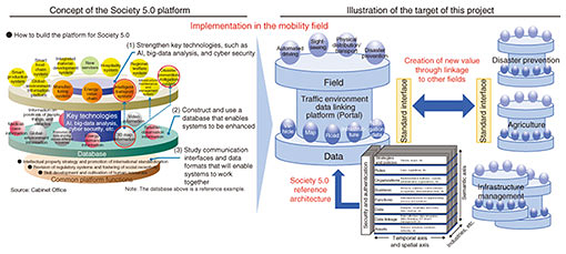
1. Importance of cooperative initiatives in the ever-advancing mobility societyAgainst the background of the need to solve various social problems and advances in technology, several mobility-related concepts and projects have been proposed and executed such as automated driving, mobility as a service (MaaS), and smart cities in which new value is created by putting those concepts into practice. Since the mobility-related market is expected to offer new business opportunities, it is a competitive area with both new and old information and communication technology providers pitted against each other, including automakers, information technology (IT)-platform providers, navigation-service providers, as well as related software/hardware vendors. These providers also need to cooperate to expand this market. Backed by the policies of the national government, local governmental organizations, such as municipalities, are also actively promoting smart cities that exploit the Internet of Things (IoT). Mobility is at the core of initiatives by which municipalities try to improve their regional transport systems. Mobility is characterized by the existence of two different domains: a public domain involved in building social infrastructures, encompassing both institutional and hardware aspects, and a business domain of private companies providing advanced services. There are a number of initiatives in the public domain, such as technical development to reinforce Japan’s competitive edge and vitalize the mobility market, and implementation of measures to enhance social receptivity to automated driving and other new services. In undertaking these initiatives, it is important to create a cooperation domain in which those involved in the development and provision of services can collaborate with the public sector so that the mobility of all segments of society can rapidly improve. As well as being engaged in business areas that create new services, NTT DATA is working on initiatives that involve collaboration with the public sector and that are intended to enhance the overall quality of life throughout society. This article introduces some of NTT DATA’s activities in two programs: the automated driving program, which is executed as part of the strategic innovation program (SIP) promoted by the Cabinet Office, Government of Japan, and a program entitled “Research for design and development of autonomous driving/drive assistance architectures,” which was conducted by the Ministry of Internal Affairs and Communications in fiscal years 2018 and 2019. 2. Activities in the SIP automated driving systemThe cross-ministerial SIP is “a new program in which the Council for Science, Technology and Innovation acts as the command organization and promotes scientific and technological innovations by managing the program across conventional ministerial and industrial boundaries.” The program consists of two phases: the first phase (fiscal years 2014–2018) and the second phase (fiscal years 2018–2022). Various projects have been established to address the different challenges that automated driving presents. The first phase focused on autonomous cruising systems while the second phase is addressing automated driving (expansion of systems and services). In the first phase, we at NTT DATA worked on the multi-purpose use of a high-precision three-dimensional (3D) road-surroundings map called a dynamic map. We conducted a demonstration experiment to investigate the possibility of using mobile-mapping-system data, which are created to produce a dynamic map for autonomous cruising, for the maintenance of communications and power facilities. The following describes the activities for the “Research for design and development of autonomous driving/drive assistance architectures” program. These activities are being undertaken in the second phase (Fig. 1).
A key to achieving Society 5.0, conceived by the government to solve social problems, is to link data individually held by the national government, municipalities, and private organizations to allow the use of data and provision of services across industrial and organizational boundaries. The goal is to dramatically increase the productivity of all activities through the highly integrated fusion of cyberspace and the physical space. Our study of the autonomous driving/drive assistance architecture is intended to enable the traffic-environment data used by vehicles and social infrastructures to be integrated and used in other fields. We are working on the three initiatives shown in Fig. 1. The first initiative is to build and operate a portal site. This is the core of our activities. The dynamic-map and road-traffic data, which are produced for automated driving, and data sent from vehicle probes can also be used in other industries. Therefore, we are studying and promoting a mechanism with which these data can be shared securely and conveniently. We are also studying how the traffic-environment data can be integrated with SIP studies on other issues, such as disaster prevention and infrastructure management (Fig. 2).
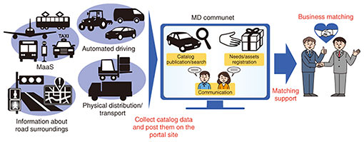
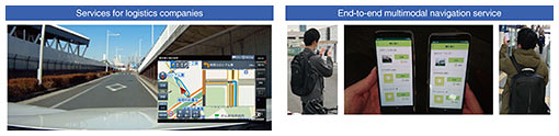
The role of this portal is to serve as a business-matching site that functions as a data depository in the mobility field and helps create new businesses. The data are stored in the form of data catalogs. These data can be searched using a normal key search. They have also been analyzed and given semantic attributes using various methods so that data can be displayed in ways that will provide opportunities for encountering new data. For example, graphs created by automatic classification and the degree of proximity of similar data are displayed so that data users can discover or become aware of new data. In addition to assisting business matching online, we are planning to provide such opportunities offline. For example, the portal site will provide a function that enables users to communicate with each other freely and carry information about offline events, both open and closed/semi-closed events, in which a limited scope of participants can hold business discussions. Therefore, we plan to launch a variety of activities that promote data utilization on the basis of our understanding of direct needs/assets of users, demand and supply of data, and trends in data usage. We are also building a demonstration system to show how effective it is to combine different types of data. A wide variety of data are being collected in the Tokyo waterfront area, where a demonstration experiment of automated driving is being carried out, and in cities visited by many tourists such as Kyoto. Data can be used by different types of users for different purposes, such as sightseeing, disaster prevention, logistics, and commercial activities. Our second initiative involves the construction of a demonstration system for a logistics service and a personal navigation service using automated-driving vehicles in the same Tokyo waterfront area (Fig. 3). Our third initiative is a demonstration experiment in an urban area (Kyoto City), in which service providers participate in a contest of app that uses data provided by both the public and private sectors.
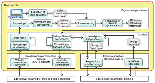
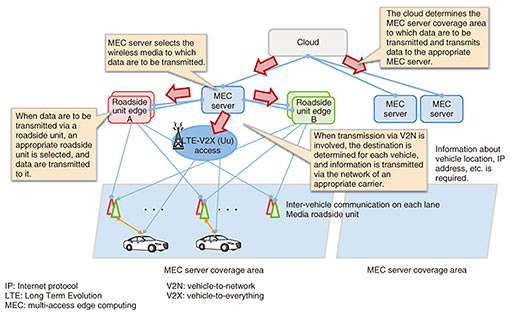
Throughout the present fiscal year (2020), we will intensify our activities by making the portal site available to the public, publicizing our projects at various events, and extending invitations to a wide audience to participate in this portal. 3. Research for achieving a connected-car societyWhen services for connected cars are introduced, the volume of data exchanged by vehicles will increase dramatically. To ensure reliable, robust, and real-time communication, the Ministry of Internal Affairs and Communications is promoting studies on advanced use of frequencies. They include upgrading existing systems, appropriate introduction of new wireless technologies, combined use of different radio systems for intelligent transport systems (ITS), and a platform that enables efficient use of data. As part of these studies, NTT DATA has carried out, in collaboration with NTT Network Technology Laboratories and NTT Communications, research and demonstration experiments of technologies required in the coming era of connected cars. The study subjects have included high-speed data processing and a data-platform infrastructure needed for control and management of multiple radio frequencies for ITS. To study the data-platform infrastructure, we developed several use cases that incorporated different types of vehicle behavior, classified them according to the following four criteria, and investigated the system architecture of the data-platform infrastructure. (1) Immediacy: whether the use case needs to be implemented as quickly as possible or designed to be used for analyses and improving precision. (2) Usage: whether the use case is mainly designed to provide services to vehicles or to interwork with external servers. (3) Locality: whether the use case requires the collection of data over a wide area or can work even with data collected from a small area. (4) Data volume: whether the use case collects only a small amount of data, such as location data, or a large amount of data, such as video data. Study items for the above system architecture included allocation of functions to cloud servers and edge servers, connection configuration, and logical topology for each use-case category. We conducted a demonstration experiment based on these study items. The aim of the experiment was to identify implementation-related technical issues in providing services. The configuration of the data platform infrastructure for the demonstration experiment is shown in Fig. 4.
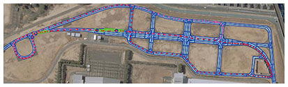
MQTTS (Message Queueing Telemetry Transport) was adopted as the communication protocol for vehicle-information collection and obstacle-information transmission. It is a representative communication protocol using the pub-sub model. We decided that it is suitable for collecting vehicle information because its header size is smaller than that of HTTPS (Hypertext Transfer Protocol Secure), thus is also suitable for transmission of IoT data. We adopted the dynamic-map specification for the map data used for identifying lanes and used the high-precision 3D map of the Japan Automobile Research Institute (JARI) test course (Jtown) (Fig. 5).
In this experiment, we examined two use cases: generation of obstacle-estimation information for each lane and collection of fixed-cycle continuously recorded images. A traffic pylon, which served as an obstacle, was placed on the test course. As vehicles drove along the course avoiding the traffic pylon, images taken with vehicle-mounted cameras were collected. We verified whether the obstacle can be estimated based on vehicle location and behavior information. The measured location information matched the map information at a lane-resolution level since Jtown is located in a field with a clear view of the sky, and JARI’s high-precision 3D map was accurate. As a result, the behavior of avoiding the traffic pylon was successfully determined. However, it was not possible to distinguish obstacle-avoiding behavior from normal lane changes. The experiment clarified issues requiring additional study. For example, estimation of obstacle-avoiding behavior needs to take other factors into account, such as reduction in vehicle speed and behavior of multiple vehicles. Based on the above investigation of a system architecture for the data-platform infrastructure and demonstration experiment, we identified the following technical issues that need to be resolved before implementation (Fig. 6).
If we are to achieve a highly optimized connected-car society through cooperation between the public and private sectors, it will be necessary to solve these problems through social implementation that involves a wide range of stakeholders. 4. Future activitiesIt will be mainly private companies that will drive development of new technologies and creation of innovation services in the automotive field. Society will demand that social problems be solved by combining various data and functions proposed by Society 5.0. For these reasons, it will be essential to create an environment that facilitates such activities. We also believe that it will not be possible to optimize mobility of all segments of society unless automated vehicles can access a common data platform at high speed via multiple means of communication. To achieve such a society, NTT DATA, and broadly the NTT Group, will study what form a service platform that can serve as a social infrastructure should take through communication with owners of assets, such as vehicles and infrastructures, and service-developing companies, and undertake research and development to build a next-generation social infrastructure. |
||